
Recording Butterflies
One of the questions I am most often asked is “why should we record butterflies?”. To put it simply we wouldn’t know anything about our local butterflies if it wasn’t for the army of dedicated volunteers who send in their records each year. The valuable data that is sent in gives us the tools to monitor species trends, it can be used to see how successful conservation work has been, and it is also essential when advising landowners on how best to manage their land for the benefit of the butterflies in their locality. There also can be a misconception that we are only interested in the butterflies at key sites. This is not true! The Purple Emperors in the woodlands, the Meadow Browns in the fields and the Red Admirals, Peacocks and Holly Blues in the gardens are all very valuable records which, when submitted, will be added to the county database and preserved for the future. Each year the annual datasets are sent to Butterfly Conservation's head office to be included in the national database and they are also sent to the local records centre, in our case the Northamptonshire Biodiversity Records Centre (NBRC). So, by sending in records you will really be putting your area, and your local butterflies, on the map! As they are so susceptible to change butterflies are great natural indicators so these records can give us a good idea about how our biodiversity is fairing.
There are various surveys you could take part in which will mentioned further down the page but if you would primarily like to take part in what is known as casual recording (this is recording butterflies anywhere you find yourself, whether that be in the garden, on a walk, or recording at butterflies one of our top butterfly sites) then the absolute best way of submitting that data is via the iRecord online platform. These days at least 75% of the 25,000 to 30,000 records I receive each year are submitted in this way. There is a very good reason for this, iRecord is very user-friendly and it also helps me as all the records can be downloaded at the end of the year for inclusion into our county database. iRecord has a website and once you have set yourself up a free account you can input wildlife records from all taxa which should all then go to the relevant county recorders in your area. I would like to stress at this point that although iRecord is my preferred method for you to send in your records if you are reading this in a neighbouring county it is worth checking with your local county recorder in case they have a different method they would rather you use. Once you are on the website and you are logged in it is just a case of clicking the RECORD drop-down menu at the top of the screen and following the simple online prompts. If you are only interested in recording butterflies, and you possess a smartphone, the iRecord platform has developed the superb iRecord Butterflies app. This is by far the best way to record butterflies in the field, and it has the added benefit of using your phone’s GPS to get the exact location of the record. This app is so good it’s the method I use when I’m out recording! The data gained by using this method has been groundbreaking as the high-quality data can be used to make extremely accurate distribution maps. For example, when monitoring the Wood White in Salcey Forest the data received from the iRecord Butterflies mobile phone app will be so detailed you can see exactly what rides the Wood Whites are using, and often more importantly, which rides they’re not using so we can see that there is something down those rides that the Wood White doesn’t like so perhaps we can do something to change that.
If you would prefer to send records to me manually that is fine too, and if you would like any help with identification please contact me using the Contact page on this website. If you would like to submit data annually the best thing to do is to fill out a spreadsheet, a template for this can be downloaded here - Northamptonshire Casual Butterfly Recording Form. The only caveat with this form is that each species has to be recorded line by line. If more than one species is recorded on a line I won’t be able to import the data into our recording software. I have included a few examples of my records from Glapthorn Cow Pastures last year as an example (please delete these before sending yours in of course). For getting high-resolution gird references in the field I can recommend using the Ordnance Survey’s OS Locate App (go into settings and change co-ordinates to National Grid and then select 10 figure grid reference format), the Tomstrails GPS OS app (only for iPhone) and also the GridPoint GB app (only for iPhone). If you are at home one of the best websites is the Bedfordshire Natural History Society’s Grab a Grid Reference tool.
Lastly a quick word about GDPR. All records sent to me will be forwarded, in their entirety, to Butterfly Conservation and the Northamptonshire Biodiversity Records Centre, so these records will include recorder names. However, I often get asked by land managers for records so they can manage their conservation efforts at their sites. When sending butterfly records to these third parties all recorder names will be removed from the data.
iRecord Butterflies App Tutorial
The iRecord Butterflies app is very user-friendly and simple to use. Don’t let the length of this tutorial put you off as it is a step-by-step guide, once you are familiar with the app it only takes a few seconds to record a butterfly. Once the app is opened you press the green butterfly icon at the bottom of the screen to start the process of recording a butterfly. Preferably key species should be recorded individually to get the most precise locations of them, but when recording the commoner species that often fly in good numbers the species list can be the best option. To start a species list do what is known as “long pressing” the green butterfly icon, this simply means pressing the button and holding you finger momentarily until the species list option pops up.

At the next stage you will see the New Sighting screen. This is where you input your details of the record. At the top you will see the Species box. Clicking on this will bring you to the species screen which is illustrated below.

The clever thing is, as the phone uses your GPS it will know your rough location so it will prioritise the butterflies that you are most likely to see in that area to save you from having to scroll through all the species to find the one you want to record. If you are unsure of the butterfly you can press the semi-circle on the top right of each species picture to learn more about if and see more pictures.

Once you have chosen the species you would like to record you will be brought back to the New Sightings screen where you can add the rest of the details. If you are recording in the field you won’t need to touch the date option as it will automatically select today’s date. You only need to select if you are adding historic records form previous days if you didn’t have the chance to add them at the time.
Next, select the location option. This will bring you to a map on which you can select your exact whereabouts. The trick to this is to tap the target icon which is below the layers icon at the top right of the map. This button will tell your GPS to get a fix on your location. The more times you tap this icon the better the resolution the GPS will get a fix to. Don’t worry it only takes a few taps to get a little box to appear which will be your exact location and you can also tap the map to add the location manually if you prefer. The only real limitation to this is if you are in an area with no mobile phone signal as it won’t be able to show the map. However, the GPS will still work, so tap the target icon a few times until you see the little box appear and this will be your location.
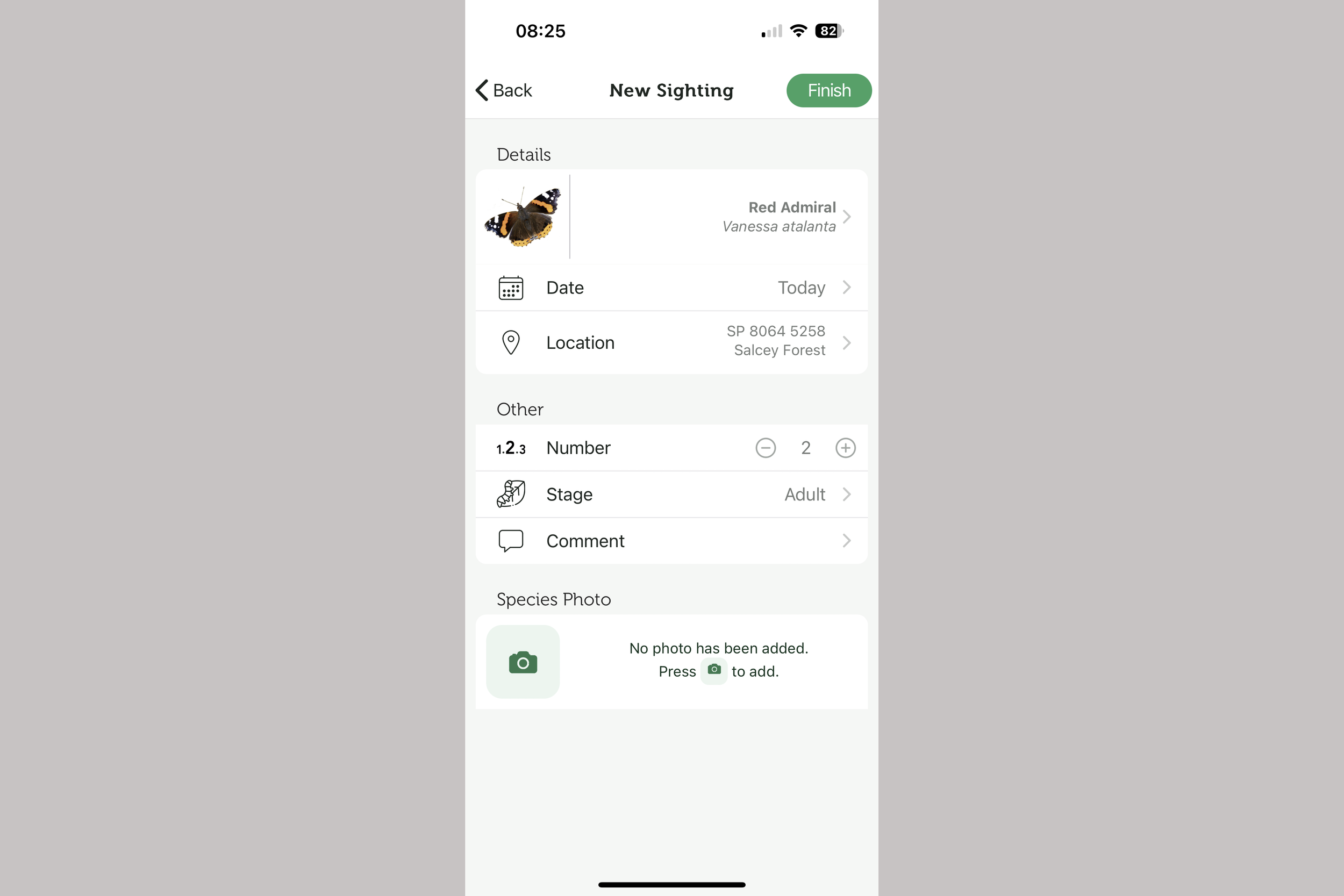
Next, you select the abundance so input the amount of that species you have seen. If for example you have seen two Red Admirals in Salcey Forest the screen will look like the one below.
An additional function that has been added to the iRecord app is the ability to record early stages which you can find under the Number box. You can then also add a comment if you wish, or click the Camera option if you would like to submit a photograph with the record too. Once you are finished inputting all of the data click the Finish button at the top of the screen. This will bring you to the records screen which will show you your pending records (these are records that haven’t yet been uploaded), your uploaded records and also the map.
If you decide to add a Species List the method is very similar to the above except you will be brought to the New List screen. When here treat the date section in the same way that is mentioned above and then select the Location. As this is a list the location option is slightly different as now it wants a centroid location and once you have selected it it will ask you for a rough size of the area being recorded. Once you have set up the area go down to the Add Species button and select the species you see on your survey. As each one is added you have the option of adding to the count. If you accidentally press too many click on the species name and alter it accordingly. Keep adding the species that you have seen and the list will look similar to the one below.

Once you have completed your list press the Finish button at the top to return to the records screen. The last thing to remember to do is to upload the record. If you have only added a couple of records the option to upload will be next to each record but if you gather several records the upload option is conveniently at the top of the screen. By pressing this you can upload all of your records at once.

Once you have uploaded all of your records that’s all you need to. They will be sent to me for verification and, once verified, you will get a notification to say that they have been accepted. Occasionally, I may have a question about a record if it’s an unusual sighting so you may receive a comment or a query.
Official Surveys
Butterfly Conservation has a number of official surveys you can take part in. The United Kingdom Butterfly Monitoring Survey (the UKBMS) is an incredibly useful survey. It is quite high effort as it requires a survey to be done weekly between April and September. However, the data gained via the UKBMS is incredibly useful when it comes to monitoring trends. We are very lucky here in Northamptonshire to have several dedicated recorders who have been walking their chosen transect routes weekly for years. We are always looking for more transects to be surveyed so if you have a local patch that you visit regularly why not set up a transect! The next survey is the Wider Countryside Butterfly Survey (the WCBS), this is a much lower-effort survey than the UKBMS and simply requires two visits to a square each year, one in July and another in August. The WCBS system works on a selection of randomly generated grid squares so you will need to find a vacant one which you think you will be able to do and then get set up to monitor it. For a list of vacant Northamptonshire WCBS squares click here. We have some recorders who like to monitor and record the butterflies they see in their garden, if this is something you would like to do then the Garden Butterfly Survey may be the right survey for you! Lastly, we have Butterfly Conservation’s Big Butterfly Count which takes place each year. This survey runs from mid July to early August each year and is one of the biggest citizen science butterfly surveys in the world!
Links
The United Kingdom Butterfly Monitoring Survey - The UKBMS